Midland Dioxin

Dioxin Exposure Study


Client: University of Michigan, Ann Arbor

Background

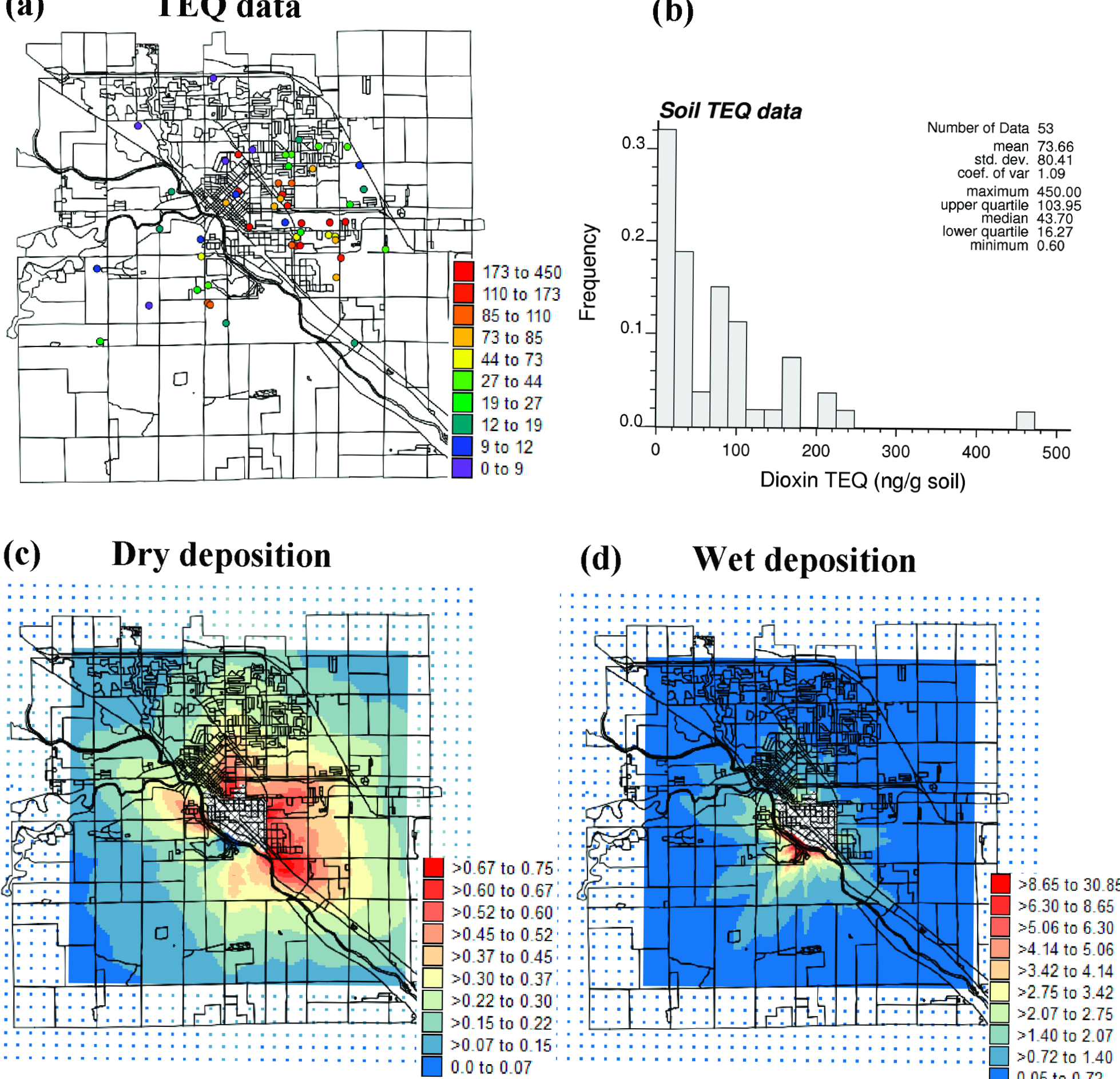
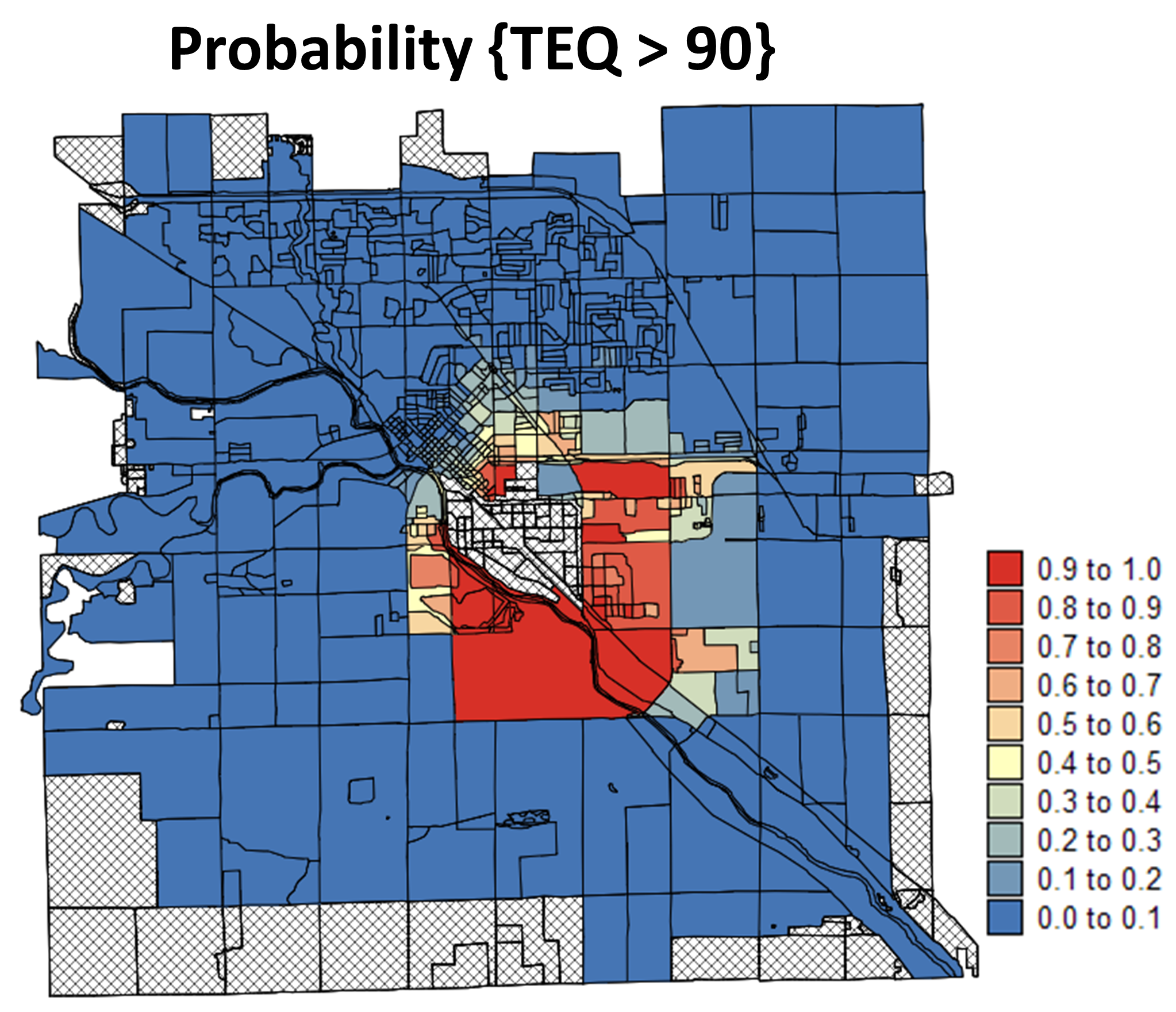
Elevated levels of dioxins have been found in the soil of the Tittabawassee River flood plain and nearby areas. Beginning in the fall of 2004, the University of Michigan was conducting a two-year study to find out whether the elevated levels of dioxins in the soil in the city of Midland, and in the Tittabawassee River flood plain between Midland and Saginaw, have also caused elevated levels of dioxins in residents' bodies.

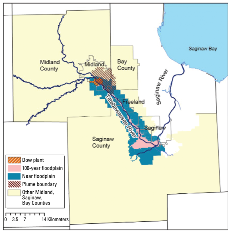
The study area is the vicinity of the Dow Chemical Company facility in Midland, Michigan. Since the 1940s, areas North-East of the Dow facility have been exposed to the deposition of dioxins resulting from incinerator outfall. Two types of incinerator facilities were used to dispose of solid wastes contaminated with halogenated compounds, including dioxins. During high temperature incineration, so-called de novo chemical synthesis processes take place resulting in the formation of polychlorinated dibenzo-p-dioxins (PCDD) and dibenzofurans (PCDF) as by-products which are then dispersed from the smoke stack. Whereas prior to 1970 incineration was fairly inefficient resulting in the formation, dispersion and deposition of higher concentrations of these by-products, modernization of the facilities since 2000 to a high efficiency (99.9999% destruction of dioxins) incinerator resulted in significant source reduction of emissions. With a prevailing N.E. wind direction, the emission plume impacted the downwind communities. It is assumed that the measured elevated soil dioxin concentrations, ranging from 1-500 ppt (ng/g soil), are largely the result from emission plume deposition prior to the 1980s.

Objectives

The objectives of this project were to:

  1. delineate areas with high level of dioxin TEQDF-WHO98 (Toxic Equivalents) around an incinerator:
  2. provide guidance for the study design (census block-based population sampling) of the University of Michigan Dioxin Exposure Study (UMDES), focused on quantifying exposure pathways to dioxins from industrial sources, relative to background exposures.

Results

  • A geostatistical simulation-based methodology was developed to combine the detailed process-based modeling of atmospheric deposition from the incinerator (output of the EPA Industrial Source Complex (ISC3) dispersion model) with the probabilistic modeling of residual variability of field samples.
  • Stochastic simulation was used to identify the census blocks that have a high probability of exceeding a given level of dioxin TEQ. This geostatistical model, along with population data, provided guidance for the collection of 51 new soil data, which permits the verification of the geostatistical predictions.
  • Probability intervals computed from simulated TEQ values provide an accurate model of uncertainty: the proportion of observations that fall within these intervals exceeds what is expected from the model. Simulation-based probability intervals are also narrower than the intervals derived from the global histogram of the data, which demonstrates the greater precision of the geostatistical approach.
Midland Map

Midland Maps
Midland TEQ Map

Publications

  1. Goovaerts, P., Trinh, H.T., Demond, A.H., Franzblau, A., Garabrant, D., Gillespie, B., Lepkowski, J., and P. Adriaens. 2008. Geostatistical modeling of the spatial distribution of soil dioxin in the vicinity of an incinerator. 1. Theory and Application to Midland, Michigan. Environmental Science & Technology, 42(10), 3648–3654.
  2. Goovaerts, P., Trinh, H.T., Demond, A.H., Towey, T., Chang S.-C., Gwinn, D., Hong, B., Garabrant, D., and P. Adriaens. 2008. Geostatistical modeling of the spatial distribution of soil dioxin in the vicinity of an incinerator. 2. Verification and calibration study. Environmental Science & Technology, 42(10), 3655-3661.